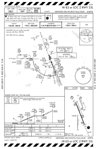
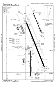


KSPS - Sheppard Afb/Wichita Falls Muni
Located in Wichita Falls, United States
ICAO - SPS, IATA - SPS
Data provided by AirmateGeneral information
Coordinates: N33°59'20" W98°29'31"
Elevation is 1019 feet MSL.
Magnetic variation is 05° East View others Airports in Texas
Operational data
Special qualification required
Current time UTC:
Current local time:
Weather
METAR: KSPS 261652Z 23014KT 10SM FEW050 27/14 A2967 RMK AO2 SLP032 T02670139
TAF: KSPS 261737Z 2618/2718 23019G25KT P6SM SCT035 FM270100 16012G18KT P6SM SKC FM270800 17014G21KT P6SM BKN015 PROB30 2715/2718 3SM TSRA BKN035CB
Communications frequencies: [VIEW]
Runways:
| RWY identifier | QFU | Length (ft) | Width (ft) | Surface | LDA (ft) |
| 15C | 158° | 10003 | 150 | OTHER | |
| 33C | 338° | 10003 | 150 | OTHER | |
| 15R | 158° | 13101 | 300 | CONC | |
| 33L | 338° | 13101 | 300 | CONC | |
| 15L | 158° | 6000 | 150 | OTHER | |
| 33R | 338° | 6000 | 150 | OTHER | |
| 18 | 180° | 7021 | 150 | ASPH | |
| 36 | 0° | 7021 | 150 | ASPH |
Airport contact information
Address: Wichita Falls United States