


KSKX - Taos Rgnl
Located in Taos, United States
ICAO - SKX, IATA - TSM
Data provided by AirmateGeneral information
Coordinates: N36°27'6" W105°40'23"
Elevation is 7094 feet MSL.
Magnetic variation is 09° East View others Airports in New Mexico
Operational data
Special qualification required
Current time UTC:
Current local time:
Weather
METAR: KSKX 030056Z AUTO 30015G20KT 10SM CLR 17/M18 A3000 RMK AO2 SLP120 T01671178
Communications frequencies: [VIEW]
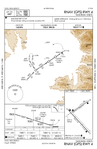
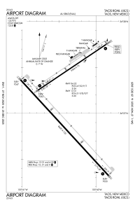
Runways:
| RWY identifier | QFU | Length (ft) | Width (ft) | Surface | LDA (ft) |
| 04 | 56° | 5504 | 75 | ASPH | |
| 22 | 236° | 5504 | 75 | ASPH | |
| 13 | 137° | 8600 | 100 | CONC | |
| 31 | 317° | 8600 | 100 | CONC |
Airport contact information
Address: Taos United States