


KSKF - Kelly Fld
Located in San Antonio, United States
ICAO - SKF, IATA - SKF
Data provided by AirmateGeneral information
Coordinates: N29°23'3" W98°34'52"
Elevation is 690 feet MSL.
Magnetic variation is 04° East View others Airports in Texas
Operational data
Special qualification required
Current time UTC:
Current local time:
Weather
METAR: KSKF 261800Z AUTO 16012KT 7SM BKN023 OVC028 27/21 A2976 RMK AO2 CIG 022 RWY34 SLP071 $
TAF: TAF KSKF 261800Z 2618/2800 14015G25KT 9999 BKN020 BKN040 OVC250 QNH2976INS TEMPO 2618/2623 9000 -TSRA BKN025CB OVC040 BECMG 2700/2701 14015G22KT 9999 SCT040 BKN120 BKN250 QNH2963INS TEMPO 2701/2705 14015G25KT BECMG 2705/2706 13010KT 9999 OVC012 QNH2966INS BECMG 2716/2717 14012KT 9999 BKN020 OVC030 QNH2972INS TEMPO 2717/2800 14017G28KT TX30/2622Z TN23/2712Z
Communications frequencies: [VIEW]
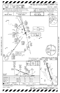
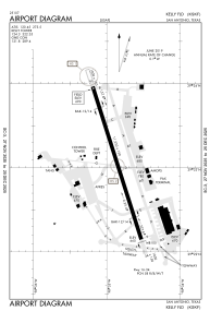
Runways:
| RWY identifier | QFU | Length (ft) | Width (ft) | Surface | LDA (ft) |
| 16 | 162° | 11550 | 150 | CONC | |
| 34 | 342° | 11550 | 150 | CONC |
Airport contact information
Address: San Antonio United States