


KSFO - San Francisco Intl
Located in San Francisco, United States
ICAO - SFO, IATA - SFO
Data provided by AirmateGeneral information
Coordinates: N37°37'8" W122°22'32"
Elevation is 13 feet MSL.
Magnetic variation is 14° East View others Airports in California
Operational data
Special qualification required
Current time UTC:
Current local time:
Weather
METAR: KSFO 300456Z 27016KT 10SM FEW032 12/07 A3006 RMK AO2 PK WND 29027/0422 SLP179 T01170072
TAF: KSFO 300301Z 3003/0106 28020G37KT P6SM SKC FM300500 29012G20KT P6SM SKC FM301500 29010KT P6SM SKC FM302000 29020G28KT P6SM SKC
Communications frequencies: [VIEW]
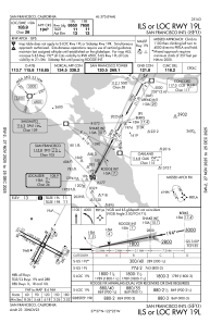
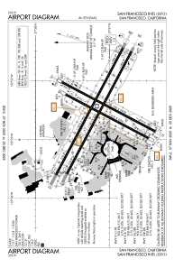
Runways:
| RWY identifier | QFU | Length (ft) | Width (ft) | Surface | LDA (ft) |
| 01L | 28° | 7650 | 200 | ASPH | 7010 |
| 19R | 208° | 7650 | 200 | ASPH | 7650 |
| 01R | 28° | 8650 | 200 | ASPH | 8090 |
| 19L | 208° | 8650 | 200 | ASPH | 8650 |
| 10L | 118° | 11870 | 200 | ASPH | 11193 |
| 28R | 298° | 11870 | 200 | ASPH | 11236 |
| 10R | 118° | 11381 | 200 | ASPH | 10704 |
| 28L | 298° | 11381 | 200 | ASPH | 10275 |
Airport contact information
Address: San Francisco United States