


KSEZ - Sedona
Located in Sedona, United States
ICAO - SEZ, IATA -
Data provided by AirmateGeneral information
Coordinates: N34°50'55" W111°47'18"
Elevation is 4830 feet MSL.
Magnetic variation is 13° East View others Airports in Arizona
Operational data
Special qualification required
Current time UTC:
Current local time:
Weather
TAF: KSEZ 082320Z 0900/0924 24009G18KT P6SM SCT120 FM090500 04015G25KT P6SM SKC FM091500 VRB06KT P6SM SKC FM092000 19009G18KT P6SM SCT120 AMD NOT SKED
Communications frequencies: [VIEW]
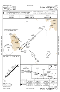
Runways:
| RWY identifier | QFU | Length (ft) | Width (ft) | Surface | LDA (ft) |
| 03 | 45° | 5132 | 100 | ASPH | |
| 21 | 225° | 5132 | 100 | ASPH | |
| H1 | 0° | 0 | 0 | UNK |
Airport contact information
Address: Sedona United States