


KSBA - Santa Barbara Muni
Located in Santa Barbara, United States
ICAO - SBA, IATA - SBA
Data provided by AirmateGeneral information
Coordinates: N34°25'34" W119°50'29"
Elevation is 13 feet MSL.
Magnetic variation is 14° East View others Airports in California
Operational data
Special qualification required
Current time UTC:
Current local time:
Weather
METAR: KSBA 300153Z 19004KT 10SM CLR 17/14 A2981 RMK AO2 SLP096 T01720144 $
TAF: KSBA 292350Z 3000/3024 15006KT P6SM SKC FM300200 31007KT P6SM SKC FM300600 VRB03KT P6SM SKC FM301600 16008KT P6SM SKC
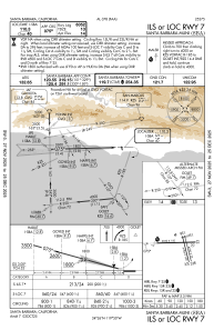
Communications frequencies: [VIEW]
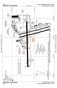
Runways:
| RWY identifier | QFU | Length (ft) | Width (ft) | Surface | LDA (ft) |
| 07 | 89° | 6052 | 150 | ASPH | 6052 |
| 25 | 269° | 6052 | 150 | ASPH | 6052 |
| 15L | 166° | 4180 | 75 | ASPH | 3963 |
| 33R | 346° | 4180 | 75 | ASPH | 4180 |
| 15R | 166° | 4184 | 100 | ASPH | 4184 |
| 33L | 346° | 4184 | 100 | ASPH | 4184 |
Airport contact information
Address: Santa Barbara United States
