


KSAD - Safford Rgnl
Located in Safford, United States
ICAO - SAD, IATA - SAD
Data provided by AirmateGeneral information
Coordinates: N32°51'12" W109°38'6"
Elevation is 3178 feet MSL.
Magnetic variation is 12° East View others Airports in Arizona
Operational data
Special qualification required
Current time UTC:
Current local time:
Weather
METAR: KSAD 261951Z AUTO VRB04KT 10SM CLR 26/M03 A2976 RMK AO2 SLP036 T02561028
Communications frequencies: [VIEW]
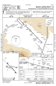
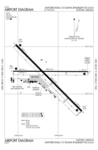
Runways:
| RWY identifier | QFU | Length (ft) | Width (ft) | Surface | LDA (ft) |
| 08 | 90° | 4802 | 60 | ASPH | |
| 26 | 270° | 4802 | 60 | ASPH | |
| 12 | 135° | 6007 | 100 | ASPH | |
| 30 | 315° | 6007 | 100 | ASPH |
Airport contact information
Address: Safford United States
