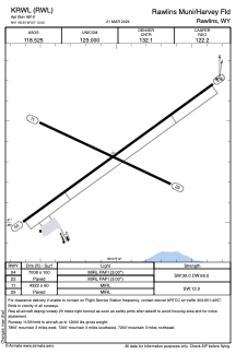


KRWL - Rawlins Muni/Harvey Fld
Located in Rawlins, United States
ICAO - RWL, IATA -
Data provided by AirmateGeneral information
Coordinates: N41°48'21" W107°12'1"
Elevation is 6816 feet MSL.
Magnetic variation is 10° East View others Airports in Wyoming
Operational data
Special qualification required
Current time UTC:
Current local time:
Weather
METAR: KRWL 281053Z AUTO 00000KT 10SM SCT065 M02/M04 A2993 RMK AO2 SLP123 T10221039
TAF: KRWL 281122Z 2812/2912 VRB03KT P6SM SCT100 FM281600 27015G25KT P6SM BKN100 FM281900 28018G26KT P6SM VCSH SCT040 BKN060
Communications frequencies: [VIEW]
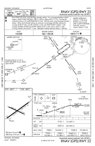
Runways:
| RWY identifier | QFU | Length (ft) | Width (ft) | Surface | LDA (ft) |
| 04 | 54° | 7008 | 100 | ASPH | |
| 22 | 234° | 7008 | 100 | ASPH | |
| 11 | 115° | 4322 | 60 | ASPH | |
| 29 | 295° | 4322 | 60 | ASPH |
Airport contact information
Address: Rawlins United States