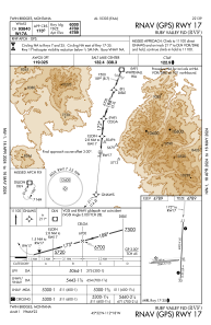
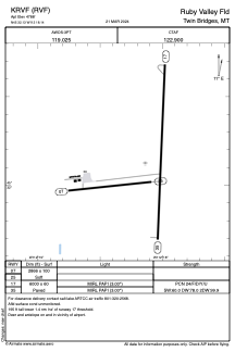


KRVF - Ruby Valley Fld
Located in Twin Bridges, United States
ICAO - RVF, IATA -
Data provided by AirmateGeneral information
Coordinates: N45°32'8" W112°18'8"
Elevation is 4788 feet MSL.
Magnetic variation is 12° East View others Airports in Montana
Operational data
Special qualification required
Current time UTC:
Current local time:
Weather at : KDLN - Dillon ( 37 km )
METAR: KDLN 262353Z AUTO 08006KT 10SM SCT050 OVC080 11/02 A2970 RMK AO2 SLP037 T01060017 10128 20083 55002
Communications frequencies: [VIEW]
Runways:
| RWY identifier | QFU | Length (ft) | Width (ft) | Surface | LDA (ft) |
| 07 | 83° | 2866 | 100 | OTHER | |
| 25 | 264° | 2866 | 100 | OTHER | |
| 17 | 182° | 6000 | 60 | ASPH | |
| 35 | 2° | 6000 | 60 | ASPH |
Airport contact information
Address: Twin Bridges United States