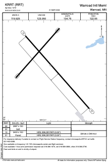


KRRT - Warroad Intl Meml
Located in Warroad, United States
ICAO - RRT, IATA -
Data provided by AirmateGeneral information
Coordinates: N48°56'29" W95°20'54"
Elevation is 1075 feet MSL.
Magnetic variation is 04° East View others Airports in Minnesota
Operational data
Special qualification required
Current time UTC:
Current local time:
Weather
METAR: KRRT 260755Z AUTO 15012G16KT 10SM CLR 12/04 A2981 RMK AO2
Communications frequencies: [VIEW]
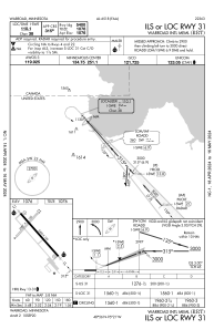
Runways:
| RWY identifier | QFU | Length (ft) | Width (ft) | Surface | LDA (ft) |
| 04 | 42° | 2987 | 150 | GRASS | |
| 22 | 222° | 2987 | 150 | GRASS | |
| 13 | 139° | 5400 | 100 | ASPH | |
| 31 | 319° | 5400 | 100 | ASPH |
Airport contact information
Address: Warroad United States