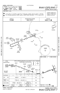
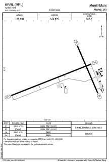


KRRL - Merrill Muni
Located in Merrill, United States
ICAO - RRL, IATA -
Data provided by AirmateGeneral information
Coordinates: N45°11'56" W89°42'46"
Elevation is 1318 feet MSL.
Magnetic variation is -01° East View others Airports in Wisconsin
Operational data
Special qualification required
Current time UTC:
Current local time:
Weather
METAR: KRRL 262015Z AUTO 13015G24KT 10SM SCT090 OVC120 14/00 A2992 RMK AO2 T01351001 TSNO
Communications frequencies: [VIEW]
Runways:
| RWY identifier | QFU | Length (ft) | Width (ft) | Surface | LDA (ft) |
| 07 | 69° | 5100 | 75 | ASPH | |
| 25 | 249° | 5100 | 75 | ASPH | |
| 16 | 157° | 2997 | 75 | ASPH | |
| 34 | 337° | 2997 | 75 | ASPH |
Airport contact information
Address: Merrill United States