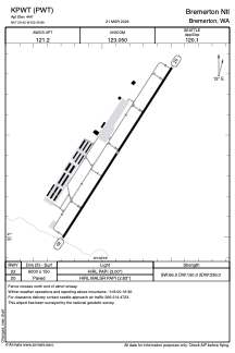


KPWT - Bremerton Ntl
Located in Bremerton, United States
ICAO - PWT, IATA - PWT
Data provided by AirmateGeneral information
Coordinates: N47°29'25" W122°45'53"
Elevation is 444 feet MSL.
Magnetic variation is 16° East View others Airports in Washington
Operational data
Special qualification required
Current time UTC:
Current local time:
Weather
TAF: KPWT 261741Z 2618/2718 22008KT P6SM VCSH BKN020 OVC050 FM262000 21007KT P6SM VCSH SCT025 OVC060 FM270600 20004KT P6SM OVC050 FM271000 20006KT P6SM BKN015 OVC050 TEMPO 2710/2714 3SM BR OVC008
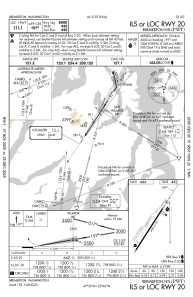
Communications frequencies: [VIEW]
Runways:
| RWY identifier | QFU | Length (ft) | Width (ft) | Surface | LDA (ft) |
| 02 | 33° | 6000 | 150 | ASPH | |
| 20 | 213° | 6000 | 150 | ASPH |
Airport contact information
Address: Bremerton United States
