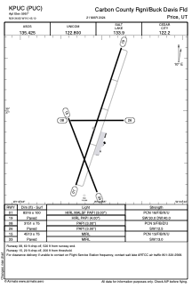


KPUC - Carbon County Rgnl/Buck Davis Fld
Located in Price, United States
ICAO - PUC, IATA -
Data provided by AirmateGeneral information
Coordinates: N39°36'50" W110°45'6"
Elevation is 5957 feet MSL.
Magnetic variation is 11° East View others Airports in Utah
Operational data
Special qualification required
Current time UTC:
Current local time:
Weather
METAR: KPUC 262208Z AUTO 18016G26KT 10SM -RA BKN034 BKN045 OVC050 08/05 A2964 RMK AO2 PK WND 20030/2157 WSHFT 2148 P0000 T00830050
Communications frequencies: [VIEW]
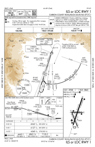
Runways:
| RWY identifier | QFU | Length (ft) | Width (ft) | Surface | LDA (ft) |
| 01 | 18° | 8316 | 100 | ASPH | |
| 08 | 90° | 3151 | 75 | ASPH | |
| 15 | 158° | 4513 | 75 | ASPH | |
| 19 | 198° | 8316 | 100 | ASPH | |
| 26 | 270° | 3151 | 75 | ASPH | |
| 33 | 338° | 4513 | 75 | ASPH |
Airport contact information
Address: Price United States