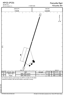


KPCD - Perryville Rgnl
Located in Perryville, United States
ICAO - PCD, IATA -
Data provided by AirmateGeneral information
Coordinates: N37°52'7" W89°51'44"
Elevation is 371 feet MSL.
Magnetic variation is 00° East View others Airports in Missouri
Operational data
Special qualification required
Current time UTC:
Current local time:
Weather
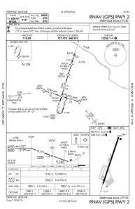
METAR: KPCD 271815Z AUTO 17016KT 10SM OVC029 21/19 A3002 RMK AO2 T02140185
Communications frequencies: [VIEW]
Runways:
| RWY identifier | QFU | Length (ft) | Width (ft) | Surface | LDA (ft) |
| 02 | 17° | 7003 | 100 | CONC | 6483 |
| 20 | 197° | 7003 | 100 | CONC | 6483 |
Airport contact information
Address: Perryville United States