


KOLM - Olympia Rgnl
Located in Olympia, United States
ICAO - OLM, IATA - OLM
Data provided by AirmateGeneral information
Coordinates: N46°58'10" W122°54'9"
Elevation is 207 feet MSL.
Magnetic variation is 15° East View others Airports in Washington
Operational data
Special qualification required
Current time UTC:
Current local time:
Weather
METAR: KOLM 261454Z 21004KT 10SM FEW032 SCT043 BKN050 10/09 A2983 RMK AO2 SLP100 T01000089 53010
TAF: KOLM 261142Z 2612/2712 23004KT P6SM FEW008 SCT030 BKN070 FM261700 22004KT P6SM VCSH BKN015 OVC025 FM262000 23008KT P6SM VCSH SCT020 OVC060 FM270800 VRB04KT P6SM OVC025
Communications frequencies: [VIEW]
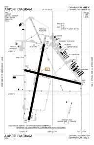
Runways:
| RWY identifier | QFU | Length (ft) | Width (ft) | Surface | LDA (ft) |
| 08 | 104° | 4157 | 150 | ASPH | |
| 26 | 284° | 4157 | 150 | ASPH | |
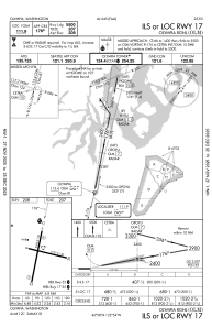
| 17 | 191° | 5500 | 150 | ASPH | |
| 35 | 11° | 5500 | 150 | ASPH |
Airport contact information
Address: Olympia United States
