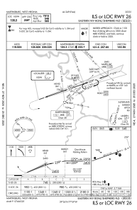
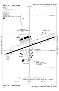


KMRB - Eastern Wv Rgnl/Shepherd Fld
Located in Martinsburg, United States
ICAO - MRB, IATA - MRB
Data provided by AirmateGeneral information
Coordinates: N39°24'8" W77°58'59"
Elevation is 564 feet MSL.
Magnetic variation is -08° East View others Airports in West Virginia
Operational data
Special qualification required
Current time UTC:
Current local time:
Weather
METAR: KMRB 161753Z 35009G16KT 10SM BKN060 24/14 A2977 RMK AO2 SLP077 T02390139 10239 20167 58006
TAF: KMRB 161730Z 1618/1718 36006KT P6SM SCT250 FM162000 36008KT P6SM BKN080 BKN250 FM170600 03003KT P6SM BKN060 FM171000 00000KT 3SM BR SCT020 FM171200 06002KT 4SM BR BKN010 FM171700 11004KT P6SM BKN035
Communications frequencies: [VIEW]
Runways:
| RWY identifier | QFU | Length (ft) | Width (ft) | Surface | LDA (ft) |
| 08 | 71° | 8815 | 150 | OTHER | 8215 |
| 26 | 251° | 8815 | 150 | OTHER | 7815 |
Airport contact information
Address: Martinsburg United States
