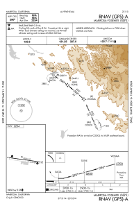
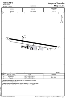


KMPI - Mariposa-Yosemite
Located in Mariposa, United States
ICAO - MPI, IATA - RMY
Data provided by AirmateGeneral information
Coordinates: N37°30'39" W120°2'22"
Elevation is 2254 feet MSL.
Magnetic variation is 15° East View others Airports in California
Operational data
Special qualification required
Current time UTC:
Current local time:
Weather at : KMCE - Merced Yosemite Rgnl ( 49 km )
METAR: KMCE 260553Z AUTO 34008KT 10SM OVC085 16/07 A3004 RMK AO2 SLP171 60000 T01610067 10222 20161 51015
TAF: KMCE 260520Z 2606/2706 26010KT P6SM SCT060 FM261800 32012G20KT P6SM OVC050 FM270300 31006KT P6SM BKN100
Communications frequencies: [VIEW]
Runways:
| RWY identifier | QFU | Length (ft) | Width (ft) | Surface | LDA (ft) |
| 08 | 100° | 3305 | 60 | ASPH | |
| 26 | 280° | 3305 | 60 | ASPH |
Airport contact information
Address: Mariposa United States
Other aviation service providers
Flight schools

Airborrn Aviation Services, Llc
Airborrn Aviation Services, Llc
airborrnaviation@gmail.com+1(209)966-2143