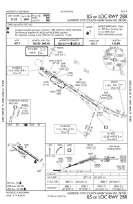
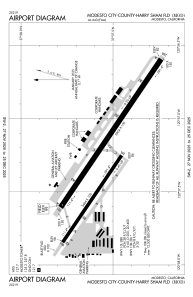


KMOD - Modesto City-County-Harry Sham Fld
Located in Modesto, United States
ICAO - MOD, IATA - MOD
Data provided by AirmateGeneral information
Coordinates: N37°37'33" W120°57'16"
Elevation is 99 feet MSL.
Magnetic variation is 16° East View others Airports in California
Operational data
Special qualification required
Current time UTC:
Current local time:
Weather
METAR: KMOD 300053Z AUTO 31013G22KT 10SM CLR 23/04 A2995 RMK AO2 PK WND 31026/0002 SLP140 T02330039
TAF: KMOD 292320Z 3000/3024 32016G25KT P6SM SKC FM300200 31012KT P6SM SKC FM301500 31015G20KT P6SM SKC
Communications frequencies: [VIEW]
Runways:
| RWY identifier | QFU | Length (ft) | Width (ft) | Surface | LDA (ft) |
| 10L | 124° | 5904 | 150 | ASPH | 5904 |
| 28R | 304° | 5904 | 150 | ASPH | 5904 |
| 10R | 124° | 3464 | 100 | ASPH | 3464 |
| 28L | 304° | 3464 | 100 | ASPH | 3464 |
Airport contact information
Address: Modesto United States
