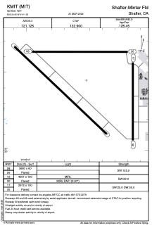


KMIT - Shafter-Minter Fld
Located in Shafter, United States
ICAO - MIT, IATA -
Data provided by AirmateGeneral information
Coordinates: N35°30'27" W119°11'32"
Elevation is 424 feet MSL.
Magnetic variation is 13° East View others Airports in California
Operational data
Special qualification required
Current time UTC:
Current local time:
Weather at : KBFL - Meadows Fld ( 15 km )
METAR: KBFL 300154Z 31007KT 10SM CLR 24/03 A2991 RMK AO2 SLP122 T02390033
TAF: KBFL 292320Z 3000/3024 33010G18KT P6SM SKC FM300300 VRB06KT P6SM SKC FM301700 31009KT P6SM SKC
Communications frequencies: [VIEW]
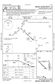
Runways:
| RWY identifier | QFU | Length (ft) | Width (ft) | Surface | LDA (ft) |
| 08 | 90° | 3680 | 60 | ASPH | |
| 26 | 270° | 3680 | 60 | ASPH | |
| 12 | 133° | 4501 | 100 | ASPH | |
| 30 | 313° | 4501 | 100 | ASPH | |
| 17 | 180° | 2972 | 100 | CONC | |
| 35 | 0° | 2972 | 100 | CONC |
Airport contact information
Address: Shafter United States