


KMFR - Rogue Valley Intl - Medford
Located in Medford, United States
ICAO - MFR, IATA - MFR
Data provided by AirmateGeneral information
Coordinates: N42°22'30" W122°52'24"
Elevation is 1335 feet MSL.
Magnetic variation is 16° East View others Airports in Oregon
Operational data
Special qualification required
Current time UTC:
Current local time:
Weather
METAR: KMFR 022353Z 29007KT 10SM SCT070 19/01 A2999 RMK AO2 RAB2259E28 SLP152 P0000 60000 T01940006 10194 20150 58004
TAF: KMFR 022339Z 0300/0324 30012KT P6SM SCT070 FM030400 32005KT P6SM SKC
Communications frequencies: [VIEW]
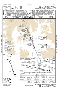
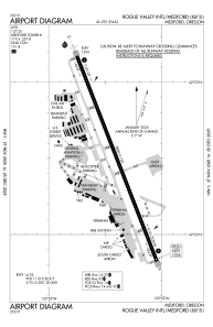
Runways:
| RWY identifier | QFU | Length (ft) | Width (ft) | Surface | LDA (ft) |
| 14 | 158° | 8800 | 150 | ASPH | 8800 |
| 32 | 338° | 8800 | 150 | ASPH | 8800 |
Airport contact information
Address: Medford United States