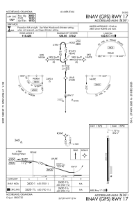
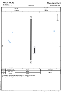


KMDF - Mooreland Muni
Located in Mooreland, United States
ICAO - MDF, IATA -
Data provided by AirmateGeneral information
Coordinates: N36°29'5" W99°11'39"
Elevation is 1970 feet MSL.
Magnetic variation is 08° East View others Airports in Oklahoma
Operational data
Special qualification required
Current time UTC:
Current local time:
Weather at : KWWR - West Woodward ( 30 km )
METAR: KWWR 050030Z AUTO 07008KT 10SM OVC033 16/10 A3004 RMK AO2
TAF: KWWR 042334Z 0500/0524 05007KT P6SM BKN040 FM050600 07008KT P6SM VCSH OVC025 FM051000 09010KT 5SM BR OVC005 FM051700 13012KT P6SM BKN025
Communications frequencies: [VIEW]
Runways:
| RWY identifier | QFU | Length (ft) | Width (ft) | Surface | LDA (ft) |
| 17 | 180° | 3500 | 60 | ASPH | |
| 35 | 0° | 3500 | 60 | ASPH |
Airport contact information
Address: Mooreland United States