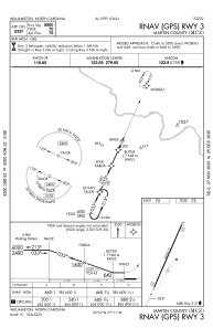
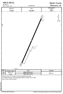


KMCZ - Martin County
Located in Williamston, United States
ICAO - MCZ, IATA -
Data provided by AirmateGeneral information
Coordinates: N35°51'44" W77°10'42"
Elevation is 74 feet MSL.
Magnetic variation is -09° East View others Airports in North Carolina
Operational data
Special qualification required
Current time UTC:
Current local time:
Weather at : KPGV - Pitt-Greenville ( 31 km )
METAR: KPGV 292205Z AUTO 24006KT 10SM CLR 28/13 A3005 RMK AO2
TAF: KPGV 291720Z 2918/3018 25010KT P6SM SKC FM300000 21005KT P6SM FEW200 FM301300 24010G17KT P6SM SCT200 AMD LTD TO CLD VIS AND WIND
Communications frequencies: [VIEW]
Runways:
| RWY identifier | QFU | Length (ft) | Width (ft) | Surface | LDA (ft) |
| 03 | 24° | 5000 | 75 | ASPH | |
| 21 | 204° | 5000 | 75 | ASPH |
Airport contact information
Address: Williamston United States