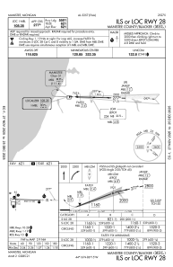
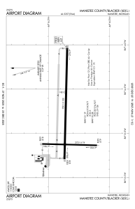


KMBL - Manistee County/Blacker
Located in Manistee, United States
ICAO - MBL, IATA - MBL
Data provided by AirmateGeneral information
Coordinates: N44°16'21" W86°14'49"
Elevation is 621 feet MSL.
Magnetic variation is -06° East View others Airports in Michigan
Operational data
Special qualification required
Current time UTC:
Current local time:
Weather
METAR: KMBL 020156Z AUTO 00000KT 10SM FEW050 10/07 A2996 RMK AO2 SLP148 T01000072
TAF: KMBL 012320Z 0200/0224 30008KT P6SM SKC FM020200 29008KT P6SM FEW250 FM020400 VRB03KT 4SM BR FEW250 FM021100 04005KT P6SM BKN070 FM022000 08008KT P6SM BKN090
Communications frequencies: [VIEW]
Runways:
| RWY identifier | QFU | Length (ft) | Width (ft) | Surface | LDA (ft) |
| 01 | 1° | 2721 | 75 | ASPH | 2721 |
| 19 | 181° | 2721 | 75 | ASPH | 2721 |
| 10 | 91° | 5501 | 100 | ASPH | 5501 |
| 28 | 271° | 5501 | 100 | ASPH | 5501 |
Airport contact information
Address: Manistee United States
