


KLWL - Wells Muni/Harriet Fld
Located in Wells, United States
ICAO - LWL, IATA - LWL
Data provided by AirmateGeneral information
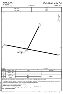
Coordinates: N41°7'2" W114°55'20"
Elevation is 5769 feet MSL.
Magnetic variation is 17° East View others Airports in Nevada
Operational data
Special qualification required
Current time UTC:
Current local time:
Weather at : KEKO - Elko Rgnl ( 80 km )
METAR: KEKO 041956Z AUTO 17022G34KT 10SM CLR 21/M03 A2956 RMK AO2 PK WND 17036/1907 SLP980 T02111028
TAF: KEKO 041734Z 0418/0518 18018G28KT P6SM BKN100 FM042000 19025G35KT P6SM BKN070 FM050000 22018G28KT 5SM -SHRA BLDU SCT025 OVC040 FM050400 26012G22KT 4SM -SHRA SCT015 OVC025 FM050600 26012G22KT 4SM -SHRASN SCT015 OVC025
Communications frequencies: [VIEW]
Runways:
| RWY identifier | QFU | Length (ft) | Width (ft) | Surface | LDA (ft) |
| 01 | 27° | 2681 | 140 | OTHER | |
| 19 | 207° | 2681 | 140 | OTHER | |
| 09 | 101° | 5508 | 75 | ASPH | |
| 27 | 281° | 5508 | 75 | ASPH |
Airport contact information
Address: Wells United States