


KLTS - Altus Afb
Located in Altus, United States
ICAO - LTS, IATA - LTS
Data provided by AirmateGeneral information
Coordinates: N34°40'5" W99°16'4"
Elevation is 1382 feet MSL.
Magnetic variation is 05° East View others Airports in Oklahoma
Operational data
Special qualification required
Current time UTC:
Current local time:
Weather
TAF: TAF AMD KLTS 011800Z 0118/0223 16015G35KT 9999 BKN016 OVC020 510003 QNH2975INS BECMG 0120/0121 15015G30KT 9999 FEW025 BKN050 510003 QNH2965INS BECMG 0123/0124 16015G25KT 8000 -SHRA VCTS BKN020CB QNH2960INS TEMPO 0201/0205 20030G50KT 4800 +TSRAGR OVC020CB BECMG 0206/0207 19012KT 9999 NSW BKN020 QNH2965INS BECMG 0214/0215 20010G20KT 9999 SCT020 QNH2970INS BECMG 0222/0223 12015KT 9999 SCT040 QNH2960INS TX29/0122Z TN16/0212Z
Communications frequencies: [VIEW]
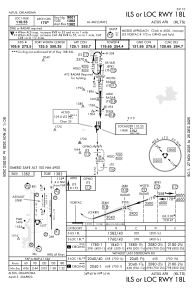
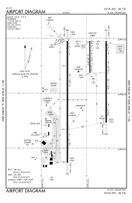
Runways:
| RWY identifier | QFU | Length (ft) | Width (ft) | Surface | LDA (ft) |
| 176 | 180° | 3500 | 90 | CONC | |
| 356 | 360° | 3500 | 90 | CONC | |
| 18L | 180° | 9001 | 150 | CONC | |
| 36R | 360° | 9001 | 150 | CONC | |
| 18R | 180° | 13440 | 150 | CONC | |
| 36L | 360° | 13440 | 150 | CONC |
Airport contact information
Address: Altus United States