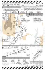
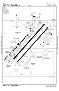


KLSV - Nellis Afb
Located in Las Vegas, United States
ICAO - LSV, IATA - LSV
Data provided by AirmateGeneral information
Coordinates: N36°14'10" W115°2'3"
Elevation is 1869 feet MSL.
Magnetic variation is 12° East View others Airports in Nevada
Operational data
Special qualification required
Current time UTC:
Current local time:
Weather
METAR: KLSV 050555Z AUTO 22028G33KT 10SM BKN130 22/M04 A2960 RMK AO2 SLP003 T02161038 10291 20216 53008 $
TAF: TAF KLSV 042300Z 0423/0605 19015G25KT 9999 FEW060 BKN140 520009 QNH2963INS TEMPO 0423/0502 21025G35KT 9000 BLDU 530009 BECMG 0501/0502 24025G39KT 9000 BLDU FEW060 BKN150 530009 QNH2954INS BECMG 0508/0509 21020G34KT 9999 NSW FEW100 BKN150 520009 QNH2966INS TX30/0423Z TN18/0514Z
Communications frequencies: [VIEW]
Runways:
| RWY identifier | QFU | Length (ft) | Width (ft) | Surface | LDA (ft) |
| 03L | 41° | 10120 | 200 | CONC | |
| 21R | 221° | 10120 | 200 | CONC | |
| 03R | 41° | 10051 | 150 | CONC | |
| 21L | 221° | 10051 | 150 | CONC | |
| H1 | 0° | 0 | 0 | UNK |
Airport contact information
Address: Las Vegas United States