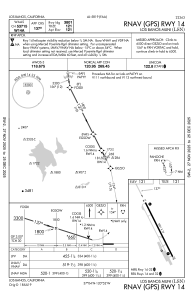
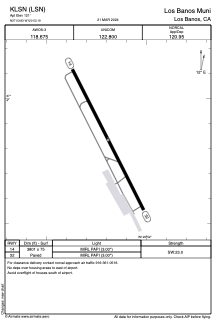


KLSN - Los Banos Muni
Located in Los Banos, United States
ICAO - LSN, IATA - LSN
Data provided by AirmateGeneral information
Coordinates: N37°3'50" W120°52'11"
Elevation is 121 feet MSL.
Magnetic variation is 16° East View others Airports in California
Operational data
Special qualification required
Current time UTC:
Current local time:
Weather at : KMCE - Merced Yosemite Rgnl ( 40 km )
METAR: KMCE 300453Z AUTO 32008KT 10SM CLR 17/07 A2996 RMK AO2 SLP143 T01720072
TAF: KMCE 292320Z 3000/3024 33016G25KT P6SM SKC FM300300 32006G19KT P6SM SKC FM300900 VRB06KT P6SM SKC FM301500 33013G21KT P6SM SKC
Communications frequencies: [VIEW]
Runways:
| RWY identifier | QFU | Length (ft) | Width (ft) | Surface | LDA (ft) |
| 14 | 153° | 3801 | 75 | ASPH | |
| 32 | 333° | 3801 | 75 | ASPH |
Airport contact information
Address: Los Banos United States