


KLNS - Lancaster
Located in Lancaster, United States
ICAO - LNS, IATA - LNS
Data provided by AirmateGeneral information
Coordinates: N40°7'20" W76°17'40"
Elevation is 402 feet MSL.
Magnetic variation is -09° East View others Airports in Pennsylvania
Operational data
Special qualification required
Current time UTC:
Current local time:
Weather
METAR: KLNS 040153Z 13005KT 10SM CLR 12/09 A3020 RMK AO2 SLP226 T01220089
TAF: KLNS 032339Z 0400/0424 13008KT P6SM SCT040 BKN150 FM040400 12008KT P6SM SCT020 BKN050 OVC100 FM040500 11007KT P6SM OVC015 FM041100 09006KT 6SM -SHRA BR BKN040 OVC120 FM041400 11006KT 4SM -SHRA BR OVC015 FM042200 12008KT 4SM -SHRA BR OVC009
Communications frequencies: [VIEW]
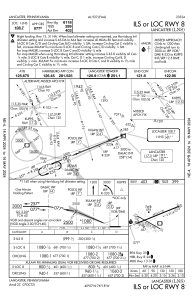
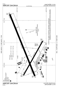
Runways:
| RWY identifier | QFU | Length (ft) | Width (ft) | Surface | LDA (ft) |
| 08 | 68° | 6933 | 150 | ASPH | 6118 |
| 26 | 248° | 6933 | 150 | ASPH | 6118 |
| 13 | 119° | 4102 | 100 | ASPH | 4102 |
| 31 | 299° | 4102 | 100 | ASPH | 4102 |
Airport contact information
Address: Lancaster United States
