


KLAW - Lawton-Fort Sill Rgnl
Located in Lawton, United States
ICAO - LAW, IATA - LAW
Data provided by AirmateGeneral information
Coordinates: N34°34'4" W98°24'60"
Elevation is 1110 feet MSL.
Magnetic variation is 06° East View others Airports in Oklahoma
Operational data
Special qualification required
Current time UTC:
Current local time:
Weather
METAR: KLAW 042253Z 01019G28KT 10SM SCT060 19/16 A2993 RMK AO2 PK WND 01028/2246 SLP129 T01940156
TAF: KLAW 041729Z 0418/0518 03012KT P6SM VCSH BKN022 BKN035 FM050300 03009G14KT 6SM SHRA BR OVC008 PROB30 0505/0511 4SM TSRA BR OVC004CB FM051300 04007G12KT 3SM -SHRA BR BKN004 PROB30 0513/0517 2SM TSRA BR OVC001CB
Communications frequencies: [VIEW]
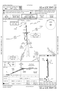
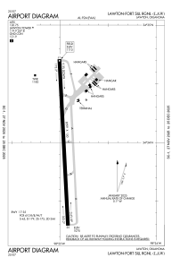
Runways:
| RWY identifier | QFU | Length (ft) | Width (ft) | Surface | LDA (ft) |
| 17 | 177° | 8599 | 150 | CONC | 8599 |
| 35 | 357° | 8599 | 150 | CONC | 8599 |
Airport contact information
Address: Lawton United States
