


KJST - John Murtha Johnstown/Cambria County
Located in Johnstown, United States
ICAO - JST, IATA - JST
Data provided by AirmateGeneral information
Coordinates: N40°18'56" W78°50'5"
Elevation is 2284 feet MSL.
Magnetic variation is -10° East View others Airports in Pennsylvania
Operational data
Special qualification required
Current time UTC:
Current local time:
Weather
METAR: KJST 260054Z AUTO 08003KT 10SM CLR 09/M03 A3023 RMK AO2 SLP250 T00891028
TAF: KJST 252348Z 2600/2624 09004KT P6SM FEW035 TEMPO 2609/2613 SCT007 BKN013 FM261300 15011G20KT P6SM BKN035
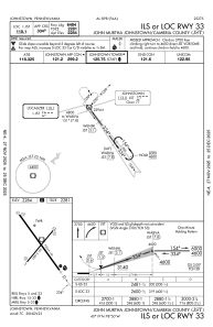
Communications frequencies: [VIEW]
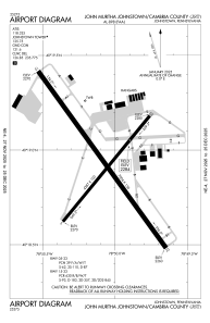
Runways:
| RWY identifier | QFU | Length (ft) | Width (ft) | Surface | LDA (ft) |
| 05 | 39° | 4387 | 100 | ASPH | 4387 |
| 23 | 219° | 4387 | 100 | ASPH | 4387 |
| 15 | 144° | 7004 | 150 | CONC | 6698 |
| 33 | 324° | 7004 | 150 | CONC | 6484 |
Airport contact information
Address: Johnstown United States
