


KJMS - Jamestown Rgnl
Located in Jamestown, United States
ICAO - JMS, IATA - JMS
Data provided by AirmateGeneral information
Coordinates: N46°55'47" W98°40'41"
Elevation is 1499 feet MSL.
Magnetic variation is 04° East View others Airports in North Dakota
Operational data
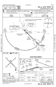
Special qualification required
Current time UTC:
Current local time:
Weather
METAR: KJMS 261256Z AUTO 14016KT 7SM -RA FEW009 BKN018 OVC028 08/06 A2965 RMK AO2 RAB1157 SLP040 P0002 T00780056
TAF: KJMS 261148Z 2612/2712 14014G21KT P6SM -SHRA BKN025 OVC035 TEMPO 2612/2614 4SM -SHRA BR BKN019 OVC025 FM261400 13014G20KT 4SM -SHRA BR SCT007 OVC011 FM261900 10013KT 4SM -SHRA BR OVC006 FM262300 07012KT 4SM -SHRA BR OVC005 FM270300 03012KT 5SM -SHRA BR OVC004 FM270800 01018G26KT 6SM -SHRA BR OVC005
Communications frequencies: [VIEW]
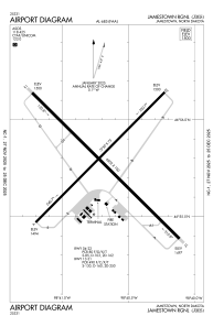
Runways:
| RWY identifier | QFU | Length (ft) | Width (ft) | Surface | LDA (ft) |
| 04 | 45° | 5750 | 75 | ASPH | 5750 |
| 22 | 225° | 5750 | 75 | ASPH | 5750 |
| 13 | 135° | 6502 | 100 | ASPH | 6502 |
| 31 | 315° | 6502 | 100 | ASPH | 6502 |
Airport contact information
Address: Jamestown United States