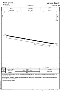


KJER - Jerome County
Located in Jerome, United States
ICAO - JER, IATA -
Data provided by AirmateGeneral information
Coordinates: N42°43'36" W114°27'24"
Elevation is 4053 feet MSL.
Magnetic variation is 14° East View others Airports in Idaho
Operational data
Special qualification required
Current time UTC:
Current local time:
Weather
METAR: KJER 272353Z AUTO 27023G30KT 10SM CLR 16/M01 A2989 RMK AO2 PK WND 27034/2310 SLP110 T01611011 10167 20128 53003
TAF: KJER 272336Z 2800/2824 27020G30KT P6SM FEW030 FM280300 27009KT P6SM SCT100 FM280500 23007KT P6SM OVC100 FM281600 27018G28KT P6SM SCT250
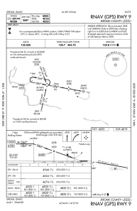
Communications frequencies: [VIEW]
Runways:
| RWY identifier | QFU | Length (ft) | Width (ft) | Surface | LDA (ft) |
| 09 | 100° | 5002 | 75 | ASPH | |
| 27 | 280° | 5002 | 75 | ASPH |
Airport contact information
Address: Jerome United States