


KICT - Wichita Dwight D Eisenhower Ntl
Located in Wichita, United States
ICAO - ICT, IATA - ICT
Data provided by AirmateGeneral information
Coordinates: N37°38'60" W97°25'59"
Elevation is 1332 feet MSL.
Magnetic variation is 04° East View others Airports in Kansas
Operational data
Special qualification required
Current time UTC:
Current local time:
Weather
METAR: KICT 300653Z 17008KT 10SM FEW110 16/11 A2985 RMK AO2 SLP099 T01610111
TAF: KICT 300535Z 3006/0106 15009KT P6SM FEW100 FM301400 17018G26KT P6SM SCT200 FM301800 19024G35KT P6SM FEW060 FM010000 22017G25KT P6SM SCT070 BKN100 FM010300 03012KT P6SM VCSH OVC060
Communications frequencies: [VIEW]
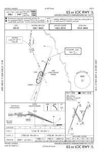
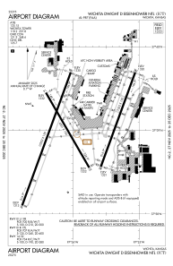
Runways:
| RWY identifier | QFU | Length (ft) | Width (ft) | Surface | LDA (ft) |
| 01L | 20° | 10302 | 150 | CONC | 10301 |
| 19R | 200° | 10302 | 150 | CONC | 10301 |
| 01R | 20° | 7302 | 150 | CONC | 7302 |
| 19L | 200° | 7302 | 150 | CONC | 7302 |
| 14 | 150° | 6301 | 150 | CONC | 6301 |
| 32 | 330° | 6301 | 150 | CONC | 6301 |
Airport contact information
Address: Wichita United States

