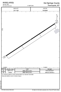


KHSG - Hot Springs County
Located in Thermopolis, United States
ICAO - HSG, IATA -
Data provided by AirmateGeneral information
Coordinates: N43°42'49" W108°23'23"
Elevation is 4891 feet MSL.
Magnetic variation is 10° East View others Airports in Wyoming
Operational data
Special qualification required
Current time UTC:
Current local time:
Weather
METAR: KHSG 260055Z AUTO 32009KT 10SM BKN090 OVC120 10/07 A2969 RMK AO2 LTG DSNT E AND SE T01000066
Communications frequencies: [VIEW]
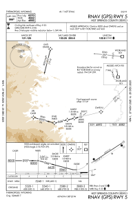
Runways:
| RWY identifier | QFU | Length (ft) | Width (ft) | Surface | LDA (ft) |
| 05 | 57° | 6370 | 75 | ASPH | |
| 23 | 237° | 6370 | 75 | ASPH |
Airport contact information
Address: Thermopolis United States