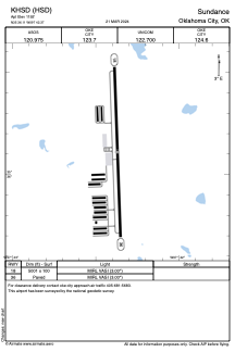


KHSD - Sundance
Located in Oklahoma City, United States
ICAO - HSD, IATA -
Data provided by AirmateGeneral information
Coordinates: N35°36'7" W97°42'22"
Elevation is 1192 feet MSL.
Magnetic variation is 04° East View others Airports in Oklahoma
Operational data
Special qualification required
Current time UTC:
Current local time:
Weather
METAR: KHSD 261915Z AUTO 19020G29KT 10SM CLR 29/10 A2958 RMK A01
Communications frequencies: [VIEW]
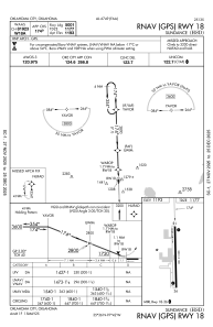
Runways:
| RWY identifier | QFU | Length (ft) | Width (ft) | Surface | LDA (ft) |
| 18 | 178° | 5001 | 100 | CONC | |
| 36 | 358° | 5001 | 100 | CONC |
Airport contact information
Address: Oklahoma City United States
