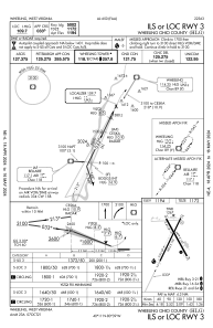
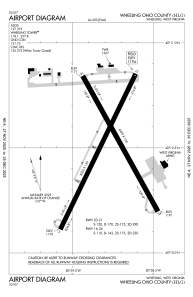


KHLG - Wheeling Ohio County
Located in Wheeling, United States
ICAO - HLG, IATA - HLG
Data provided by AirmateGeneral information
Coordinates: N40°10'30" W80°38'47"
Elevation is 1194 feet MSL.
Magnetic variation is -07° East View others Airports in West Virginia
Operational data
Special qualification required
Current time UTC:
Current local time:
Weather
METAR: KHLG 261353Z 11010KT 10SM CLR 13/06 A3025 RMK AO2 SLP249 T01330056
TAF: KHLG 261123Z 2612/2712 04005KT P6SM SKC FM261300 12010KT P6SM SCT050 FM270000 14012KT P6SM BKN150 FM271000 14010KT P6SM -SHRA OVC035
Communications frequencies: [VIEW]
Runways:
| RWY identifier | QFU | Length (ft) | Width (ft) | Surface | LDA (ft) |
| 03 | 26° | 5002 | 150 | ASPH | |
| 21 | 206° | 5002 | 150 | ASPH | |
| 16 | 151° | 4499 | 150 | ASPH | |
| 34 | 331° | 4499 | 150 | ASPH |
Airport contact information
Address: Wheeling United States