
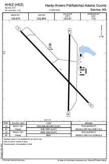


KHEZ - Hardy-Anders Fld/Natchez-Adams County
Located in Natchez, United States
ICAO - HEZ, IATA -
Data provided by AirmateGeneral information
Coordinates: N31°36'49" W91°17'50"
Elevation is 272 feet MSL.
Magnetic variation is 00° East View others Airports in Mississippi
Operational data
Special qualification required
Current time UTC:
Current local time:
Weather
METAR: KHEZ 291556Z AUTO 16006KT 10SM RA OVC090 18/17 A3002 RMK AO2 LTG DSNT S-W SLP164 P0004 T01780172
TAF: KHEZ 291238Z 2913/3012 15009KT 5SM BR VCTS SCT015CB OVC080 FM291630 16008KT P6SM FEW060 OVC100 FM292000 18007KT P6SM SCT030 OVC035 FM300600 VRB04KT P6SM BKN011 FM300800 VRB04KT 5SM BR OVC004
Communications frequencies: [VIEW]
Runways:
| RWY identifier | QFU | Length (ft) | Width (ft) | Surface | LDA (ft) |
| 14 | 136° | 6500 | 150 | ASPH | |
| 32 | 316° | 6500 | 150 | ASPH | |
| 18 | 181° | 5000 | 150 | ASPH | |
| 36 | 1° | 5000 | 150 | ASPH |
Airport contact information
Address: Natchez United States