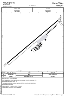


KHCR - Heber Valley
Located in Heber, United States
ICAO - HCR, IATA -
Data provided by AirmateGeneral information
Coordinates: N40°28'55" W111°25'44"
Elevation is 5636 feet MSL.
Magnetic variation is 11° East View others Airports in Utah
Operational data
Special qualification required
Current time UTC:
Current local time:
Weather at : KPVU - Provo Muni ( 38 km )
METAR: KPVU 281856Z 27005KT 10SM FEW070 BKN100 12/04 A3007 RMK AO2 SLP164 T01220044
TAF: KPVU 281721Z 2818/2918 VRB05KT P6SM SCT060 BKN100 FM281900 29010KT P6SM FEW060 SCT100 FM290400 14005KT P6SM FEW100 SCT200
Communications frequencies: [VIEW]
Runways:
| RWY identifier | QFU | Length (ft) | Width (ft) | Surface | LDA (ft) |
| 04 | 50° | 6898 | 75 | ASPH | |
| 22 | 230° | 6898 | 75 | ASPH |
Airport contact information
Address: Heber United States