
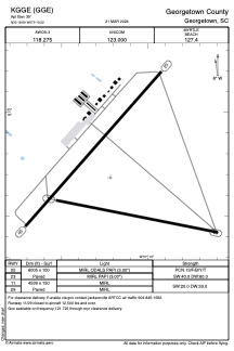


KGGE - Georgetown County
Located in Georgetown, United States
ICAO - GGE, IATA - GGE
Data provided by AirmateGeneral information
Coordinates: N33°18'41" W79°19'13"
Elevation is 39 feet MSL.
Magnetic variation is -08° East View others Airports in South Carolina
Operational data
Special qualification required
Current time UTC:
Current local time:
Weather
METAR: KGGE 261555Z AUTO 06009KT 10SM OVC015 18/15 A3030 RMK AO2
Communications frequencies: [VIEW]
Runways:
| RWY identifier | QFU | Length (ft) | Width (ft) | Surface | LDA (ft) |
| 05 | 41° | 6005 | 100 | ASPH | |
| 23 | 221° | 6005 | 100 | ASPH | |
| 11 | 101° | 4539 | 150 | ASPH | |
| 29 | 281° | 4539 | 150 | ASPH |
Airport contact information
Address: Georgetown United States