


KGCC - Northeast Wyoming Rgnl
Located in Gillette, United States
ICAO - GCC, IATA - GCC
Data provided by AirmateGeneral information
Coordinates: N44°20'56" W105°32'22"
Elevation is 4365 feet MSL.
Magnetic variation is 09° East View others Airports in Wyoming
Operational data
Special qualification required
Current time UTC:
Current local time:
Weather
METAR: KGCC 260853Z AUTO 29009KT 10SM BKN110 09/01 A2961 RMK AO2 SLP994 T00890006 50000
TAF: KGCC 260520Z 2606/2706 33008KT P6SM BKN120 FM261400 35017G27KT P6SM SCT080 BKN120 FM270200 01015G25KT P6SM BKN090
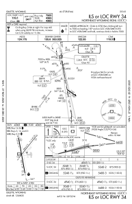
Communications frequencies: [VIEW]
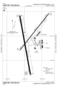
Runways:
| RWY identifier | QFU | Length (ft) | Width (ft) | Surface | LDA (ft) |
| 03 | 38° | 5804 | 75 | CONC | 5803 |
| 21 | 218° | 5804 | 75 | CONC | 5803 |
| 16 | 170° | 7501 | 150 | CONC | 7500 |
| 34 | 350° | 7501 | 150 | CONC | 7500 |
Airport contact information
Address: Gillette United States
