
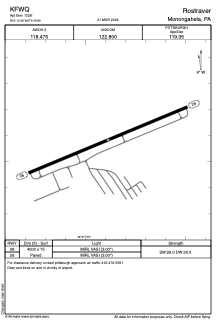


KFWQ - Rostraver
Located in Monongahela, United States
ICAO - FWQ, IATA -
Data provided by AirmateGeneral information
Coordinates: N40°12'35" W79°49'53"
Elevation is 1228 feet MSL.
Magnetic variation is -09° East View others Airports in Pennsylvania
Operational data
Special qualification required
Current time UTC:
Current local time:
Weather at : KAGC - Allegheny County ( 18 km )
METAR: KAGC 040453Z 15004KT 5SM -RA BR OVC095 18/16 A3005 RMK AO2 RAB31 SLP172 P0000 T01780161 402940156
TAF: KAGC 040521Z 0406/0506 13004KT P6SM VCSH OVC040 FM041100 12010KT P6SM VCSH BKN025 FM041700 12010G18KT 6SM -SHRA BR BKN015
Communications frequencies: [VIEW]
Runways:
| RWY identifier | QFU | Length (ft) | Width (ft) | Surface | LDA (ft) |
| 08 | 67° | 4002 | 75 | ASPH | |
| 26 | 247° | 4002 | 75 | ASPH |
Airport contact information
Address: Monongahela United States