


KFTK - Godman Aaf
Located in Fort Knox, United States
ICAO - FTK, IATA - FTK
Data provided by AirmateGeneral information
Coordinates: N37°54'25" W85°58'19"
Elevation is 754 feet MSL.
Magnetic variation is -03° East View others Airports in Kentucky
Operational data
Special qualification required
Current time UTC:
Current local time:
Weather
METAR: KFTK 261655Z AUTO 14012KT 10SM OVC060 19/11 A3009 RMK AO2 RAB37E49DZB49E51 SLP190 P0000 T01910106
TAF: TAF KFTK 261100Z 2611/2717 05006KT 9999 SCT075 OVC100 QNH3008INS BECMG 2614/2615 13010G18KT 9999 VCSH BKN025 OVC055 510053 QNH3010INS BECMG 2619/2620 15010G15KT 9999 SCT025 OVC075 510053 QNH3008INS BECMG 2705/2706 17012KT 9999 NSW SCT018 BKN025 BKN040 520053 510553 QNH3001INS BECMG 2713/2714 18020G25KT 9999 SCT015 BKN025 OVC150 520053 QNH3013INS TX19/2620Z TN11/2611Z
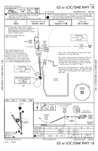
Communications frequencies: [VIEW]
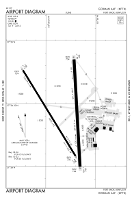
Runways:
| RWY identifier | QFU | Length (ft) | Width (ft) | Surface | LDA (ft) |
| 15 | 0° | 4853 | 75 | ASPH | |
| 33 | 0° | 4853 | 75 | ASPH | |
| 18 | 0° | 5184 | 150 | ASPH | |
| 36 | 0° | 5184 | 150 | ASPH |
Airport contact information
Address: Fort Knox United States