


KFOD - Fort Dodge Rgnl
Located in Fort Dodge, United States
ICAO - FOD, IATA - FOD
Data provided by AirmateGeneral information
Coordinates: N42°33'4" W94°11'31"
Elevation is 1156 feet MSL.
Magnetic variation is 02° East View others Airports in Iowa
Operational data
Special qualification required
Current time UTC:
Current local time:
Weather
METAR: KFOD 261856Z AUTO 13021G27KT 10SM -RA OVC008 11/09 A2960 RMK AO2 PK WND 14028/1803 LTG DSNT NW-NE RAB45 SLP037 P0000 T01110094
TAF: KFOD 261740Z 2618/2718 13018G27KT P6SM VCTS OVC007CB FM270100 14019G29KT 4SM TSRA BR OVC007CB FM270400 17016G24KT P6SM SCT010 BKN035 FM270800 21014G23KT P6SM SCT010 BKN040 FM271400 24012KT P6SM SCT040
Communications frequencies: [VIEW]
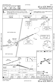
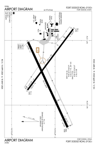
Runways:
| RWY identifier | QFU | Length (ft) | Width (ft) | Surface | LDA (ft) |
| 06 | 65° | 6547 | 150 | ASPH | 6547 |
| 24 | 245° | 6547 | 150 | ASPH | 6547 |
| 12 | 127° | 5301 | 100 | ASPH | 5301 |
| 30 | 307° | 5301 | 100 | ASPH | 5301 |
Airport contact information
Address: Fort Dodge United States
