


KERI - Erie Intl/Tom Ridge Fld
Located in Erie, United States
ICAO - ERI, IATA - ERI
Data provided by AirmateGeneral information
Coordinates: N42°4'59" W80°10'26"
Elevation is 732 feet MSL.
Magnetic variation is -10° East View others Airports in Pennsylvania
Operational data
Special qualification required
Current time UTC:
Current local time:
Weather
METAR: KERI 032351Z 13006KT 10SM OVC110 17/12 A3000 RMK AO2 SLP156 60002 T01720117 10206 20128 56016
TAF: KERI 032340Z 0400/0424 09005KT 6SM -SHRA BKN070 FM040600 14006KT P6SM SCT035 FM041500 16011KT P6SM BKN030 FM042200 15013KT P6SM BKN015
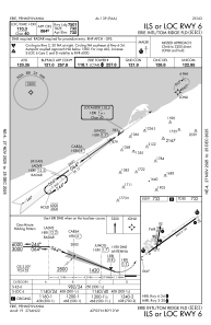
Communications frequencies: [VIEW]
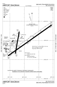
Runways:
| RWY identifier | QFU | Length (ft) | Width (ft) | Surface | LDA (ft) |
| 02 | 10° | 3508 | 150 | ASPH | 2520 |
| 20 | 190° | 3508 | 150 | ASPH | 2902 |
| 06 | 54° | 8420 | 150 | ASPH | 7501 |
| 24 | 234° | 8420 | 150 | ASPH | 7500 |
Airport contact information
Address: Erie United States
