


KELY - Ely/Yelland Fld
Located in Ely, United States
ICAO - ELY, IATA - ELY
Data provided by AirmateGeneral information
Coordinates: N39°17'59" W114°50'31"
Elevation is 6259 feet MSL.
Magnetic variation is 14° East View others Airports in Nevada
Operational data
Special qualification required
Current time UTC:
Current local time:
Weather
METAR: KELY 050353Z AUTO 17028G43KT 10SM OVC085 14/M05 A2953 RMK AO2 PK WND 15053/0323 SLP917 T01391050
TAF: KELY 042320Z 0500/0524 18035G45KT 6SM BLDU BKN100 FM050600 18025G35KT 6SM BLDU VCSH SCT025 BKN080 FM050900 23020G30KT 4SM -SHRASN SCT015 OVC025 FM051200 33012G22KT 3SM -SHSN SCT007 OVC015 FM051600 30012G22KT P6SM VCSH SCT015 OVC050
Communications frequencies: [VIEW]
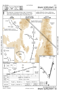
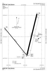
Runways:
| RWY identifier | QFU | Length (ft) | Width (ft) | Surface | LDA (ft) |
| 12 | 141° | 4825 | 60 | ASPH | |
| 30 | 321° | 4825 | 60 | ASPH | |
| 18 | 194° | 6017 | 150 | ASPH | |
| 36 | 14° | 6017 | 150 | ASPH |
Airport contact information
Address: Ely United States