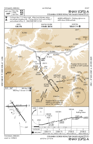
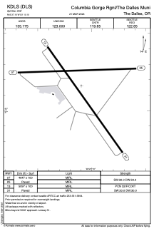


KDLS - Columbia Gorge Rgnl/The Dalles Muni
Located in The Dalles, United States
ICAO - DLS, IATA - DLS
Data provided by AirmateGeneral information
Coordinates: N45°37'10" W121°10'6"
Elevation is 246 feet MSL.
Magnetic variation is 15° East View others Airports in Oregon
Operational data
Special qualification required
Current time UTC:
Current local time:
Weather
METAR: KDLS 012053Z AUTO 32015G23KT 10SM CLR 16/01 A3013 RMK AO2 PK WND 34026/2037 SLP204 T01560011 56022
TAF: KDLS 011725Z 0118/0218 32015KT P6SM SCT150 BKN220 TEMPO 0119/0122 32012G22KT FM020200 30008KT P6SM BKN120 FM020600 30006KT P6SM BKN060 FM021200 36003KT P6SM BKN040
Communications frequencies: [VIEW]
Runways:
| RWY identifier | QFU | Length (ft) | Width (ft) | Surface | LDA (ft) |
| 07 | 88° | 4647 | 100 | ASPH | |
| 25 | 268° | 4647 | 100 | ASPH | |
| 13 | 145° | 5097 | 100 | ASPH | |
| 31 | 325° | 5097 | 100 | ASPH |
Airport contact information
Address: The Dalles United States
Other aviation service providers
Repair station

Flight schools

Gorge Aviation Services, Llc
Gorge Aviation Services, Llc
rolf@gorgeaviationservices.com+1(509)767-0005