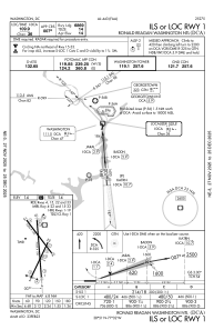
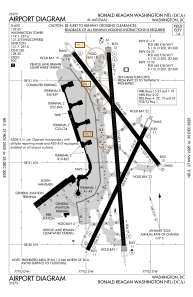


KDCA - Ronald Reagan Washington Ntl
Located in Washington, United States
ICAO - DCA, IATA - DCA
Data provided by AirmateGeneral information
Coordinates: N38°51'5" W77°2'16"
Elevation is 14 feet MSL.
Magnetic variation is -11° East View others Airports in District of Columbia
Operational data
Special qualification required
Current time UTC:
Current local time:
Weather
METAR: KDCA 050152Z 08007KT 7SM OVC007 12/11 A3023 RMK AO2 DZE52 SLP235 P0000 T01220106
TAF: KDCA 042329Z 0500/0606 09007KT 5SM -DZ BR BKN007 OVC014 FM050600 09007KT 4SM -RADZ BR OVC005 WS020/20030KT FM050800 09006KT 3SM -RADZ BR OVC005 WS020/20030KT FM051200 10006KT 3SM -RADZ BR BKN005 OVC008 FM051600 15006KT 5SM -SHRA BR SCT005 OVC008 FM051800 16006KT 6SM -SHRA BR SCT008 OVC010 FM052100 16007KT 6SM BR VCSH SCT008 BKN020 FM060000 15006KT 6SM -SHRA BR SCT006 BKN012
Communications frequencies: [VIEW]
Runways:
| RWY identifier | QFU | Length (ft) | Width (ft) | Surface | LDA (ft) |
| 01 | 356° | 7169 | 150 | ASPH | 6869 |
| 19 | 175° | 7169 | 150 | ASPH | 6869 |
| 04 | 26° | 5000 | 150 | ASPH | 4800 |
| 22 | 206° | 5000 | 150 | ASPH | 4400 |
| 15 | 143° | 5204 | 150 | ASPH | 5204 |
| 33 | 323° | 5204 | 150 | ASPH | 5204 |
Airport contact information
Address: Washington United States