


KDAF - Necedah
Located in Necedah, United States
ICAO - DAF, IATA -
Data provided by AirmateGeneral information
Coordinates: N44°2'0" W90°5'6"
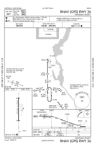
Elevation is 919 feet MSL.
Magnetic variation is -01° East View others Airports in Wisconsin
Operational data
Special qualification required
Current time UTC:
Current local time:
Weather at : KVOK - Volk Fld ( 17 km )
METAR: KVOK 262255Z AUTO 11014KT 10SM -RA FEW005 OVC013 09/07 A2981 RMK AO2 PK WND 09027/2155 RAE02RAB03E22RAB28 CIG 011 RWY27 SLP104 P0004 T00870067 $
TAF: TAF KVOK 261700Z 2617/2723 11012G18KT 9999 SCT080 SCT110 BKN150 510004 QNH2984INS TEMPO 2617/2620 10020G35KT 520004 BECMG 2622/2623 13012KT 9999 BKN030 OVC045 QNH2984INS BECMG 2703/2704 13012KT 8000 -SHRA OVC010 QNH2965INS BECMG 2715/2716 20020G25KT 9999 NSW FEW012 BKN020 OVC030 510005 QNH2962INS BECMG 2719/2720 22030G40KT 9999 BKN025 OVC035 520006 QNH2963INS TX21/2717Z TN09/2700Z LAST NO AMDS AFT 2621 NEXT 2709
Communications frequencies: [VIEW]
Runways:
| RWY identifier | QFU | Length (ft) | Width (ft) | Surface | LDA (ft) |
| 18 | 179° | 2721 | 60 | ASPH | |
| 36 | 359° | 2721 | 60 | ASPH |
Airport contact information
Address: Necedah United States