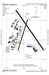


KCXO - Conroe/North Houston Rgnl
Located in Houston, United States
ICAO - CXO, IATA - CXO
Data provided by AirmateGeneral information
Coordinates: N30°21'12" W95°24'54"
Elevation is 244 feet MSL.
Magnetic variation is 05° East View others Airports in Texas
Operational data
Special qualification required
Current time UTC:
Current local time:
Weather
METAR: KCXO 261353Z 16013KT 10SM BKN019 OVC030 23/20 A2987 RMK AO2 SLP111 T02330200
TAF: KCXO 261125Z 2612/2712 16013G19KT P6SM BKN018 OVC027 FM261600 17015G25KT P6SM SCT015 BKN025 OVC150 FM261800 16016G26KT P6SM SCT025 BKN035 OVC150 FM262000 16016G26KT P6SM VCSH BKN035 OVC150 FM270000 14013G23KT P6SM SCT025 BKN035 FM270300 14011KT P6SM OVC020
Communications frequencies: [VIEW]
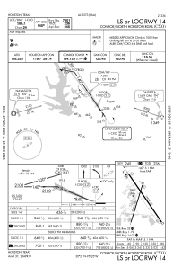
Runways:
| RWY identifier | QFU | Length (ft) | Width (ft) | Surface | LDA (ft) |
| 01 | 17° | 5000 | 100 | CONC | 5000 |
| 19 | 197° | 5000 | 100 | CONC | 5000 |
| 14 | 145° | 7501 | 150 | CONC | |
| 32 | 325° | 7501 | 150 | CONC |
Airport contact information
Address: Houston United States
