


KCOU - Columbia Rgnl
Located in Columbia, United States
ICAO - COU, IATA - COU
Data provided by AirmateGeneral information
Coordinates: N38°49'4" W92°13'4"
Elevation is 889 feet MSL.
Magnetic variation is 00° East View others Airports in Missouri
Operational data
Special qualification required
Current time UTC:
Current local time:
Weather
METAR: KCOU 281654Z 16015G20KT 10SM SCT095 SCT120 18/16 A2981 RMK AO2 PK WND 13026/1631 PRESRR SLP088 T01830161
TAF: KCOU 281720Z 2818/2918 16013G22KT P6SM VCSH OVC080 FM282200 18015G24KT 6SM SHRA BR VCTS OVC030CB FM290200 17009KT P6SM VCSH OVC035 FM291400 27008KT P6SM BKN060
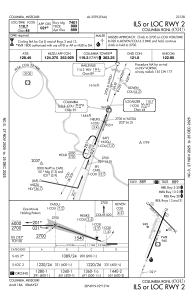
Communications frequencies: [VIEW]
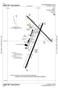
Runways:
| RWY identifier | QFU | Length (ft) | Width (ft) | Surface | LDA (ft) |
| 02 | 21° | 7401 | 150 | CONC | 6501 |
| 20 | 201° | 7401 | 150 | CONC | 6501 |
| 13 | 135° | 5500 | 100 | CONC | 5500 |
| 31 | 315° | 5500 | 100 | CONC | 5500 |
Airport contact information
Address: Columbia United States
